
The Next Most Common Question: What Are You Going to Do About Sea Level Rise?
After covering a few other topics in my blog entries, I thought this would be a good time to revisit another in the list of common questions I get from students, media, and other interested people. This one is such a meaty topic that there’s enough content for two blog entries on it…LUCKY YOU!
Here’s the first one; we’ll run Part 2 in a few weeks.
Probably the second most common question is about whether and how the tidal marsh restoration efforts will “work” in a future with higher sea levels. A related question is how we are addressing the risk of sea level rise in our project. So let’s start at the top.
Future sea level rise in San Francisco Bay is an undeniable fact, though there are still uncertainties in the amount, timing, and rates of increases in sea level. That said, each new model or projection of future sea level rise indicates that we should be preparing for higher water levels sooner than previous projections called for.
Importantly, neither of the two landowners in the South Bay Salt Pond Restoration Project, the U.S. Fish and Wildlife Service – manager of the Don Edwards San Francisco Bay National Wildlife Refuge – and the California Department of Fish and Wildlife – manager of Eden Landing Ecological Reserve – is a flood protection agency. Their primary missions and bases of technical expertise are a long way from planning for long-term coastal flooding related to sea level rise.
Accordingly, the Restoration Project’s legal responsibility is to at least maintain current levels of de facto flood risk management. To do that, any place where our actions, such as breaching former salt-production pond berms, would cause a decrease in existing protection, we raise and otherwise improve levees to offset that decrease. Where possible, we also work with local flood protection or public works agencies to incorporate other levee or water management structure improvements or strategies to increase the current levels of flood risk management.
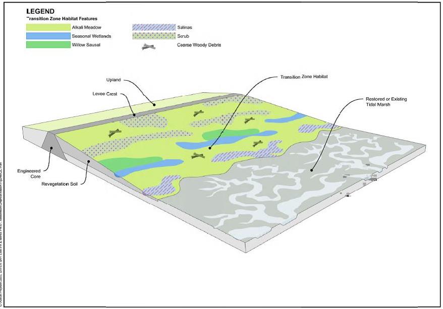
Our designs also include several different aspects of sea level rise adaptation. For example, we are working to establish tidal marshes, which act like sponges to slow, spread out, or even hold back high waters related to peak high tides, storm surge, and wave run-up. At the landward edge of many of our tidal marshes, we are building habitat transition zones, which are gentle slopes that connect uplands to the bottoms of ponds or the marshes we restore. These sloped habitats further blunt wave run-up, storm surge, and high tides. They also provide a "ramp" for marshes to migrate uphill in the future as marsh plants grow on newly deposited sediments brought in by the tides. These slopes are also important habitats for wildlife that need to escape high water levels as sea levels rise.
Our work to improve existing levees can also provide the base for future increases in levee heights as needed to protect against rising waters. This strategy involves building a wider base than is needed for guarding against today’s flood risks so that additional elevation can be added later without requiring additional areas of fill or habitat impacts.
Most research and sea level rise projections show that established marshes and sloped habitats in the South Bay can keep pace with sea level rise for another few decades, if tides and creeks continue to deliver the same amount of sediments. So it’s important to restore as much tidal marsh as we can now to get it established before the expected highest rates of sea level rise occur.