


Visiting the Pond Complexes
 Don Edwards San Francisco Bay National Wildlife Refuge
Visit the Restoration
Find out about current trail closures and construction
Volunteer and Interpretive Activities at Alviso Ponds
Waterfowl Hunting
More than 10,000 acres are open for waterfowl hunting. See the Refuge's hunting page for more information.
Virtual Tour of Alviso
Tour the Mallard Slough Trail at the Alviso ponds virtually via this San Francisco Bay Wildlife Society webpage.
Environmental Education Center (Trails, Views, Interpretive Displays)
The Environmental Education Center offers access to trails and a boardwalk through seasonal wetland habitat, making it easy to see and explore the natural wonders of the South Bay. It is also a site for tours offered by the non-profit San Francisco Bay Wildlife Society. Please note that Environmental Education Center programs are currently limited due to nearby levee construction from the South San Francisco Bay Shoreline Project. Most public programs are planned during the early evenings or on Sundays. Trails are open 7 days a week from Sunrise to Sunset. If the gates are locked please park and walk in to enjoy the trails.
Directions: From I-880 or Highway 101, exit on Highway 237 toward Alviso. Turn north onto Zanker Road. Continue on Zanker Road to the Environmental Education Center entrance road (a sharp right turn at Grand Blvd.) The distance from Hwy. 237 to the entrance road is 2.1 miles.
Disabled Access: It is Refuge policy to accommodate individuals with disabilities. If you have any questions or if you need any accommodation to enable you to participate in the Refuge's programs, please leave a message for a public use staff person at the Refuge Headquarters at 510-792-0222.
Interpretive Programs: Refuge naturalists and volunteers, as well as staff from the non-profit San Francisco Bay Wildlife Society, offer a wide variety of guided programs, walks, and other activities. You can find out about programs on our Events page; the Refuge website's Activities and Events pages; and the Wildlife Society website.
Trails: The Refuge is crisscrossed by miles of hiking trails. The most popular trails near the Environmental Education Center include New Chicago Marsh and Alviso Slough Trail. Trails are periodically closed due to levee maintenance. Check at the Visitor Center and Environmental Education Center for the latest trail information.
Note: The Mallard Slough Trail, closed during habitat enhancement construction, has reopened with altered alignments and distances.
Fishing: A public fishing pier is located at the end of Marshlands Road at the refuge headquarters in Fremont and is open year-round. Birds, particularly the threatened western snowy plover, occasionally nest along Marshlands Road from April 1 - August 31. If birds are found nesting along this road, Marshlands Road will close to protect them. A free shuttle service is offered on weekends during these months. Call the Refuge for closure information. Fish commonly caught are rays, leopards sharks, white sturgeon, striped bass, and shiner surfperch. Check the California State Fishing Regulations for restrictions.
Hunting: The Refuge offers sites for waterfowl hunting mid-October to mid-January. Check the California Waterfowl Regulations each season for opening and closing dates. All hunting areas are boat-access only, except for Ravenswood. Additional information is available in the Visitor Center. A special use permit for hunting is required.
Boating: Canoes and kayaks are recommended, since motorboats disturb wildlife. Many sloughs are empty of water at low tide. Please be aware of the tide schedule before you embark. If your boat becomes stuck in the mud, wait for the next high tide to float it free. Public launching ramps are located at Redwood City and near the Refuge Visitor Center. For more information, see the San Francisco Bay Water Trail's page on the Alviso Marina County Park boat launch, or Santa Clara County Parks' page on Alviso Marina County Park.
Alviso Marina County Park (Trails)
This 18.9-acre bayside park provides opportunities for picnicking and birdwatching, as well as access to other public lands for seasonal hiking and mountain bicycling.
Directions: The Marina is located at the end of Hope Street, which can be reached by taking Lafayette Street north from Santa Clara or 1st Street northwest from San Jose. Lafayette turns into Gold Street. 1st Street turns into Taylor Street, which intersects Gold Street. Turn right onto Gold Street. Continue on Gold Street, which turns left and becomes Elizabeth Street. Elizabeth T's onto Hope Street. Turn right and go over the bridge to the Marina. From the Peninsula, take Hwy 101 to Hwy 237, get off at the Great America Parkway exit, turn left, then follow the road for a short distance until it hits Gold Street. Then turn left. From the East Bay, take 880 to 237 to the 1st Street exit. Turn right and follow 1st Street to Gold Street as above.
Mountain View Pond Trail and Shoreline at Mountain View Park (Trails, Views)
Info on construction-related trails impacts
New 1.2-mile Bay Trail spur opened, extending Stevens Creek Trail!
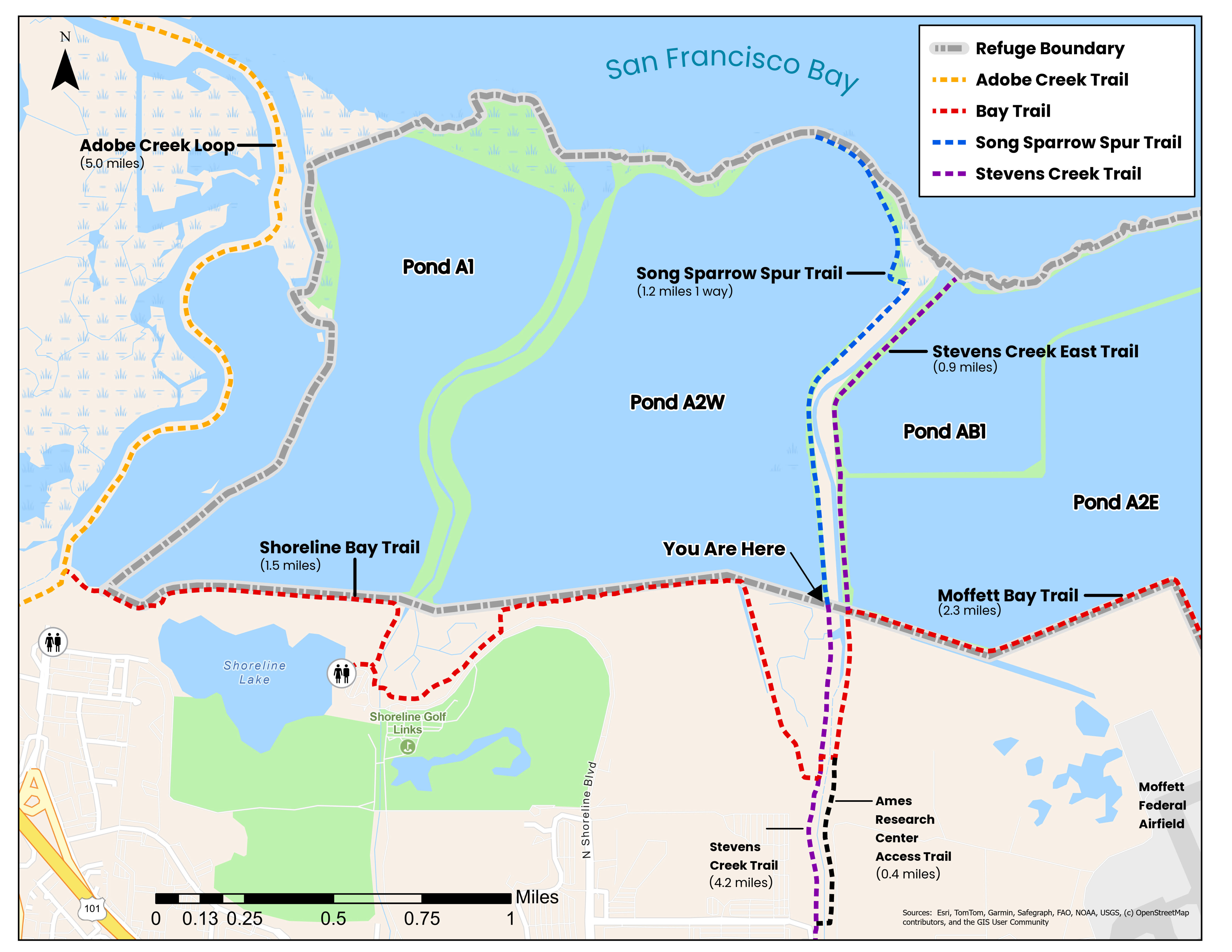
The Refuge in early 2026 opened this new Song Sparrow Spur Trail along Pond A2W, leading to views of open Bay waters. The all-weather trail crosses two bridges, and includes benches. Interpretive signs will be installed by the end of 2026. Shoreline at Mountain View Park is west of Stevens Creek near the Bay, upland from Refuge lands. This beautiful 700-acre park includes a saltwater lake, golf course, rolling grassy hills, and trails. The park's 50-acre lake is popular with wind surfers and small boaters. The strong bay winds make the park a favorite place for stunt kite flying. The park has 10 miles of trails, some paved, some dirt. Paved trails lead past the golf course, around the lake, and along the tidal marshes and salt ponds. Some trails lead northwest to Palo Alto's Baylands Nature Preserve. Next to Shoreline Park is the Shoreline Amphitheatre. It's hard to believe it was built on mountains of trash, as the 500 acres were used as a landfill from 1968 to 1981. In 1983, Mountain View closed the dump and began turning it into a park.
Directions: To reach Shoreline at Mountain View directly from the south, take Hwy 101 to the Shoreline Blvd. exit. Shoreline Blvd. leads directly into the main entrance of the park. From the north, take Hwy 101 south, exit at Amphitheatre Parkway, then turn left at Shoreline Blvd. to the park entrance. To find the new Song Sparrow Spur Trail, which has not yet been added to area trail maps, you can use this Bay Trail map to find the north, Bayside end of Stevens Creek Trail. The start of the Shoreline Trail is near the Crittenden Lane Trailhead. Crittenden Lane is east off Shoreline Blvd. before the entrance to the park. The back side of the park can be reached by taking Hwy 101 to the San Antonio Avenue off-ramp and heading north. San Antonio turns right at Terminal Blvd. There is parking along Terminal Blvd. Trails lead into the west side of the park. The park can also be reached from the Bay Trail along East Bayshore Road from Palo Alto, or back along the Palo Alto Baylands Marsh trail.